
Land Board Grants 65-year Lease For Oʻahu’s First Resilience Hub
Last month, the Department of Land and Natural Resources’s Land Division recommended granting a 10-year lease for nearly five acres in the back of Hauʻula to the nonprofit Hui O Hauʻula.
The organization has spearheaded efforts spanning more than a decade to build a resilience hub in the community that could also serve the rest of Koʻolau Loa, which is extremely vulnerable to natural disasters, with the single, coastal road connecting the small towns to the rest of the island eroding in many places.
According to a Land Division report to the Board of Land and Natural Resources, Koʻolau Loa is the only district on Oʻahu that lacks a designated hurricane shelter. The closest one is Kahuku Elementary School, which sits within an area designated as having a minimal flood hazard.
“Therefore, there is a compelling need for the Koʻolau Loa community to have the critical lifelines that can be provided through the resilience hub: safety and security, food, water, shelter, health and medical services, energy, communications, transportation and waste management technology,” the report states.
In March 2023, the Land Board granted the Hui a three-year lease for “community services and activities purposes.” The lease helped the Hui raise funds to build the hub and also gave the group time to complete the state’s environmental review process.
An environmental assessment for the hub — including a three-story shelter and structures for storage and community activities, among other things — was completed last July.
“Through their hard work, HOH has applied for and obtained several grants for the Resilience Hub totaling approximately $6,000,000 from various organizations and government entities. In addition, with the help of a grant from the [City & County of Honolulu], a 40-foot container was placed on-site that is filled with 1,500 five-gallon buckets (family-size) of dehydrated food that is stored onsite for emergencies/disasters. HOH has applied for and been awarded several federal grants and is awaiting the status of the award amount. However, recent changes at the federal level have created uncertainty as to whether HOH will receive funding,” the Land Division report continues, referring to widespread efforts by the Trump administration to slash federal funding.
At the Land Board’s March 28 meeting, Hui executive director Dotty Kelly-Paddock testified that the group was very focused on constructing a building that can protect people from Category 5 hurricanes.
“This property is so perfect for us,” she said of the state parcel located well out of most flood zones. Although a portion of the property would be vulnerable to an “extreme tsunami,” the shelter will be constructed in a safer, mauka corner of the lot, according to the EA.

“In the meantime, we’re also going to be growing agroforestry there for our communities” and a medicinal garden, as well as building traditional Hawaiian hale that have already been permitted by the city, she said.
“With all the disruption in Washington, we just lost our 2025 earmark, which was another $5.5 million. We applied for a [2026] earmark. Hopefully, we can get that and continue the construction, but a long-term lease is really critical when working with funders,” she said. She asked that the board make the lease effective as soon as the 10-year lease documents are completed and not wait until the three-year lease expires next year.
“Now is a very critical time to say to funders we have a long-term lease, a 10-year lease. They look at that as part of deciding whether or not they will provide the funding,” she said.
To this, Land Board chair and DLNR director Dawn Chang asked whether the Hui would need a lease for longer than ten years.
“I would say yes. … Eventually, we hope to have 60-65 year lease,” Kelly-Paddock replied.
Chang noted that the title of the agenda item gave the board the flexibility to issue a longer-term lease.
Board member Kaiwi Yoon seemed to support the idea. “I think we all would support a longer-term lease given the instability of what’s going on in Washington. Our nonprofits here need long-term dispositions in order to secure adequate funding.”
Kelly-Paddock said that should the hui’s application for federal funding in 2026 fall through, the Hui still has HUD funding that’s good for eight years.
“We will still have some funding to start the horizontal infrastructure in ’26 … water, electric, and sewage,” she said.
Board member Aimee Barnes made a motion to approve a 25-year lease. Member Vernon Char seconded the motion. After a brief board discussion that included asking Kelly-Paddock what term she would prefer, Barnes amended her motion to set the term at 65 years.
Board member Riley Smith noted that for a lease that long, the board typically requires a removal bond. “There might be some issues we might be concerned with,” he said. He added that he was comfortable with requiring the posting of the bond not at the start of the lease, but after 20 years, and the motion was amended to incorporate that idea, as well.
The board unanimously approved the amended motion.
“This is so very helpful,” Kelly-Paddock said. Because Hauʻula’s will be the first resilience hub on Oʻahu, she said that the Hui is documenting its steps on the way “to share the ‘ike (knowledge) with other small communities.”
Nuisance Algae Complicates Debris Removal in Monument
The hard work of finding, hand-cutting, and removing the tons of marine debris that collect on atolls within the Papahānaumokuākea Marine National Monument has gotten harder with the spread of the nuisance algae Chondria tumulosa.
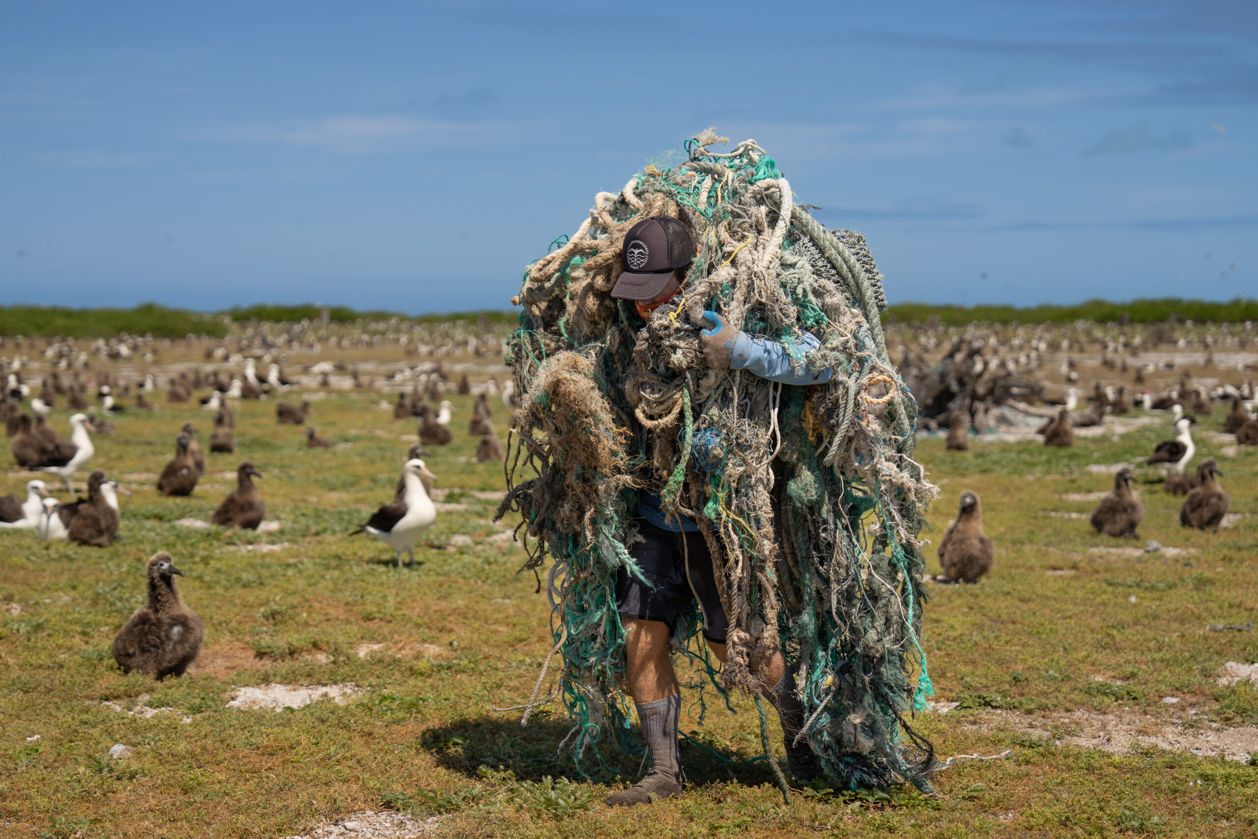
fishing gear out of a dense seabird colony. CREDIT: ANDREW SULLIVAN-HASKINS.
Discovered at Manawai (Pearl and Hermes Atoll) in 2016, the previously undocumented, mat-forming macroalgae has since been detected at Kuaihelani (Midway Atoll) and Hōlanikū (Kure Atoll). It’s blanketed hundreds of acres of reef, “smothering vast swaths of coral colonies,” according to a state Department of Land and Natural Resources website.
“When NOAA divers first detected the alga in 2016, it grew in low abundance, not yet widespread. In three years, the alga had grown into abundant mats of over 100,000 square feet each at Pearl and Hermes Atoll, outcompeting the species typically living in these ecosystems,” a NOAA website adds.
“Researchers have not yet determined if Chondria tumulosa was introduced from another region,” it continues, quoting the monument’s deputy superintendent, Randall Kosaki, who asks, “Is it a native species that was just completely overlooked until it went berserk at one atoll, or was it an accidental human introduction from somewhere else?”
Because of this uncertainty, researchers aren’t yet calling C. tumulosa invasive, “instead opting to call it a ‘nuisance’ species for its invasive-like qualities,” the site states.
Although C. tumulosa has more recently been detected in the Marshall Islands, the alga has not yet been found in the Main Hawaiian Islands. And resource managers want to keep it that way.
According to an October 2024 DLNR summary of efforts, “A joint collaboration of federal, state, and private partners created a plan to test Chondria’s ability to spread to the main Hawaiian Islands via marine debris removed from the monument.” Experiments were done to see if the algae died if it simply dried out for long enough.
Since 2022, the nonprofit Papahānaumokuākea Marine Debris Project has received permits from the Board of Land and Natural Resources and the monument’s management board to disentangle animals (Hawaiian monk seals, sea turtles, and seabirds) trapped in marine debris within the monument, and to remove the debris.
“Over the last four years, our organization removed over 1 million pounds of marine debris, 80 percent of which was derelict fishing nets,” PMDP executive director and co-founder James Morioka told the Land Board last month, as it entertained a recommendation from the DLNR’s Division of Aquatic Resources to issue a new permit to the organization for disentanglement/debris removal activities this year.
“When the fishing nets land on the coral reefs, it tends to suffocate the corals like a tarp on grass, so everything beneath will end up dying and will not provide shelter or food for fish that are really important to our native food web,” he said.
Under this year’s permit, his organization is expected to remove 100 tons of marine debris from the monument. In past years, PMDP brought the debris collected back to Honolulu, where it was burned at the H-Power plant.
“Currently, PMDP mitigates [the potential spread of C. tumulosa] by avoiding removing debris from areas with C. tumulosa growth and, when the debris is removed, thoroughly bleaching all of the material to ensure that no invasives are accidentally picked up and brought back alive to Oʻahu. However, this is dangerous for the crew, as the sloshing of large amounts of bleach in containers mid-journey creates a potential chemical hazard to those working on the boats,” the October 2024 DLNR summary states.
So far, researchers have not found a better way to kill the algae before PMDP makes its return trips back to Oʻahu.
Morioka, who managed the debris removal projects in the monument before PMDP took over from NOAA, told the board that in years past, “If we identify the algae on the net or the surrounding habitat, we have to move to an alternative location, so we leave the net in place. Unfortunately, last year we disentangled and rescued two green sea turtles and had to leave the net in place. One of my biggest concerns is these nets will continue to trap animals and to kill animals and it’s going to continue to disrupt the coral reef ecosystem and kill the coral reef beneath it. But it also serves as vector for spread. So once these fishing nests become loose from the reef, they become these floating masses of this invasive algae which can then get sucked into the current, convergence zones and bring it back to the Main Hawaiian Islands.”
He assured the board that PMDP has a “rigorous biosecurity plan to ensure that this algae doesn’t come back to our reefs.”
Nets from the islands that are infected by the algae are removed and put into marine debris storage bins. The nets are bleached “at a 10 percent solution for four hours, because that’s the only known [way] to kill this algae. Once the nets are treated, that there’s absolutely no chance of this algae surviving, then we neutralize and dilute this bleach solution, go three nautical miles offshore over one thousand feet deep … and we’re able discharge the water overboard into Papahānaumokuākea assuming that it’s neutralized. … Once it hits the big, deep ocean, it kind of dissipates and dilutes into nothing. But this method is extremely caustic and toxic for our staff. It’s been really, really difficult to work with. But this is what we have to do to ensure and safeguard the Main Hawaiian Islands and so we’re going to continue to do so,” he said.
Even so, DAR had concerns about the biosecurity plans as originally proposed — especially with regard to work planned at Kuaihelani — and it had not yet approved a supplemental biosecurity plan by the time the board met to decide on the permit. DAR recommended dividing the plan covering this year’s three removal trips into three parts, to allow some work to proceed if DAR was still reviewing a plan for one of the trips.
“This year at Kuaihelani, in April, we’re proposing to remove nets for the first time with this Chondria tumulosa on there,” Morikawa said.
PMDP is choosing to remove all debris at Kuaihelani, regardless of the presence or absence of invasive algae, “due to the hazards it poses to wildlife and the potential risk of nets remobilizing and drifting to another island or atoll,” the organization stated in its responses to questions posed by DAR that were included in DAR’s submittal to the Land Board.
Debris collected at Kuaihelani in April will be left on the atoll and not be brought to Main Hawaiian Islands for months, if at all.
Morioka said the nets will be either studied to identify other ways to kill the nuisance algae or be treated with bleach solution before being brought to Honolulu on a later trip.
For the debris that does get shipped back, “everything is craned off whole and trucked to H-Power Covanta to make sure it does not get into our waterways and conquer the reefs here,” he said.
The Land Board unanimously approved the permit.
Novel Survey in NWHI To Fill Chondria Data Gaps

HAWAI‘I.
In addition to approving the permit for marine debris removal in the Papahānaumokuākea Marine National Monument, the Land Board also approved a research permit to University of Hawaiʻi doctoral student Keolohilani Lopes, Jr. to conduct monitoring of C. tumulosa in the nearshore waters of Manawai and Lalo (French Frigate Shoals).
Later this year, Lopes and his team plan to deploy small Uncrewed Marine Systems (sUMS) — FloatyBoats and submersible RangerBots — to autonomously map C. tumulosa and collect images and other data.
Also, automated underwater covert cameras and hydrophones will be weighted and set in sandy areas surrounded by reefs six hours a day to “conduct presence absence videos of marine species and how they relate to the sound scape and disturbances. More specifically, this passive hydrophone/camera will be used to compare the soundscapes between areas with C. tumulosa and areas without,” his permit application states.
Lopes plans to create a “ChondriaBot” program that will use computer vision technology to identify and map the algae.
“The extent of C. tumulosa is a major gap in knowledge for PMNM resource managers that the ChondriaBot program aims to fill. ChondriaBot systems rely solely on camera systems and other passive imaging technologies and will not directly contact the substrate. Ancillary data collected by these sUMS are salinity, depth, temperature, and eDNA collected on filter paper. The eDNA approach will consist of a passive filtration technique designed by UH graduate researcher, Patrick Nichols. These sUMS are developed by Queensland University of Technology, where it was rigorously field tested for several years, and adapted for this specific purpose by Mr. Lopes, for the University of Hawaiʻi at Mānoa,” the application continues.
Opportunity and weather conditions will dictate where the equipment will be deployed, but the team anticipates mapping several acres a day near the fringing reefs, “where small boats find it too dangerous to access,” it states.
While the Chondria detection program runs on “AI/Machine Learning” that has achieved 86 percent overall accuracy in computer model runs, Lopes plans to test the system by reviewing all of the video collected in the monument to “manually track C. tumulosa occurrences against the computer vision detections,” it states.
— Teresa Dawson
Leave a Reply