
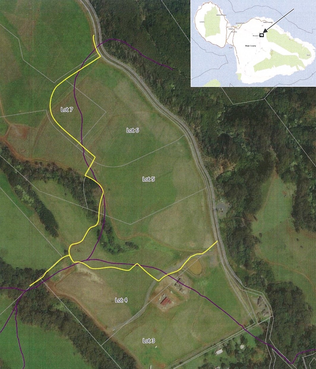
Above photo: Trail location recommended by DOFAW staff in 2021 (yellow) and “apparent location digitized by trace” from 1872 registered map 603. CREDIT: DOFAW.
On July 25, two months after its basic terms had been worked out, a stipulation for a stay of an order for injunctive relief regarding access to the historic Haleakalā Trail was finally filed with the 2nd Circuit Court.
Public Access Trails Hawaiʻi and its founder, David Brown, initiated the lawsuit seeking injunctive relief, among other things, to wrest control over use of the state trail from Haleakalā Ranch Company. The trail bisects property owned by the ranch.
The injunction was initially set to take effect on April 1, but that start date was pushed to May 22, when the court was to hear a motion by the state to modify the injunction, as well as a motion by plaintiffs PATH and Brown for an order to show cause for civil contempt.
The injunction would have prohibited anyone other than pedestrians and cultural practitioners exercising their rights or practices from using the six-foot wide, three-and-a-half mile long trail.
Before the May hearing in support of its motion to modify, the state offered declarations from a number of people and entities — including The Nature Conservancy of Hawaiʻi, adjacent property owners, Mahi Pono and the state Division of Forestry and Wildlife — that require vehicular access to Haleakalā Ranch’s Olinda gate, which lies within the trail’s path.
By that time, 2nd Circuit Judge Peter Cahill had modified the order to allow Maui Electric Company and the Maui Department of Water Supply access to the gate and portions of the trail to maintain utilities.
At the May hearing, Cahill made it clear that he wanted the historic trail surveyed and marked in accordance with the metes and bounds previously approved by the court. A declaration from Haleakalā Ranch’s president and CEO J.Scott Meidell claimed that the trail was dangerous and impassable in places due to a steep 30-foot cliff and invasive gorse. Another by DOFAW administrator David Smith suggested that it would be impracticable for his staff to cross such terrain to conduct resource management activities.
Cahill, however, wanted the trail marked where it is first, with the resolution for users that need an easier route to be worked out later.
According to PATH’s attorney Mike Biechler, the trail is not anywhere near as problematic as it had been made out to be.
PATH and David Brown dispute that a cliff or gulch make the trail inaccessible by hikers.
Biechler, in an email to Environment Hawaiʻi, noted that more than a decade ago, the court adopted findings by surveyor Anthony Crook “as the basis for the trail’s location following the 2014 trial and jury verdict [confirming that the state owned the trail]. Crook testified that the route he determined to be the historical trail in the area of the Kailua Gulch was ‘passable by pedestrians or horses.’ The dispute will likely be resolved soon as the plaintiffs and state entered, and the court approved on July 25, 2025, a stipulation to suspend the injunction to allow for the state to survey and mark the Haleakalā Trail by the end of 2025.”
Biechler stated that the state’s attorneys “have not shared anything with us indicating that they are moving forward” with the new survey. “We did a document request regarding the survey and are awaiting a response from DLNR to see if they are responsive documents,” he added.
Biechler concedes that based on his own hikes attempting to locate the trail using cell phone location services, GPS devices and drones, “yes, there is some gorse on the trail at certain points.” However, he added, “I did not encounter any sections that were so large they were impassable while staying on the trail. However, there were large patches in the area where we believe the trial to be.”
He pointed out that the July 25 the stipulation, which stays the injunctive order until January 1, “does not require the state to maintain or clear the trail so, outside of a settlement, I do not think anything that comes from this stay and pending survey marking of the trail would result in any requirement for the state to clear and maintain the trail. They have been openly hostile to the idea of doing that for the entire litigation.”
Although Crook’s report identified two passable pedestrian paths across the gulch, Biechler stated that the trail’s location is set by court judgment, “so there is no ‘wiggle room,’ but if the state and Haleakalā Ranch can reach an agreement (or if the ranch unilaterally allows the public to access certain areas to engage in recreational hiking of the trail), the public could be allowed to deviate onto ranch land to make using the trail more easy or convenient at certain locations. Right now, and for the foreseeable future, the only way the public can legally hike the trail (without being on a Sierra Club guided hike) is to stay on the state-owned 6-foot public right-of-way, so the public could not chose to go the second route to cross the gulch without trespassing and subjecting themselves to whatever civil and criminal liability goes along with that.”
With regard to the need by many for vehicular access through parts of the trail, Biechler stated that this is “somewhat separate from the locating the trail issue. PATH has never been opposed to the gate/trail being used for other sorts of access besides pedestrians, i.e., water company, Baldwin family properties inside the gate, TNCH. PATH’s position was that pedestrians must be allowed access and not be prohibited by a private company HRC from accessing public lands, that the state cannot allow HRC to prevent public pedestrian access, and that the HRC has de facto retained private ownership of the trail despite the previous court judgment.”
— Teresa Dawson