

Once more, a massive development is being proposed on a site near Waikoloa Village. If the plans of landowner Waikoloa Green, LLC, move forward, over the next two decades, some 400 apartments and around 300 single-family houses will sprout on 700 acres just south of Waikoloa Road, near its junction with Paniolo Avenue.
Its supporters point to the urgent need for additional housing on the island. Few people, including the staff of the Hawaiʻi County Planning Department and the state Commission on Water Resource Management, have bothered to question whether the water supply is sufficient to support the proposed housing, much less support agricultural activities on the bone-dry land proposed for most of the area.
As the proposal comes before the County Council for decision-making this month, the question remains of where the water will come from.
The Red Zone
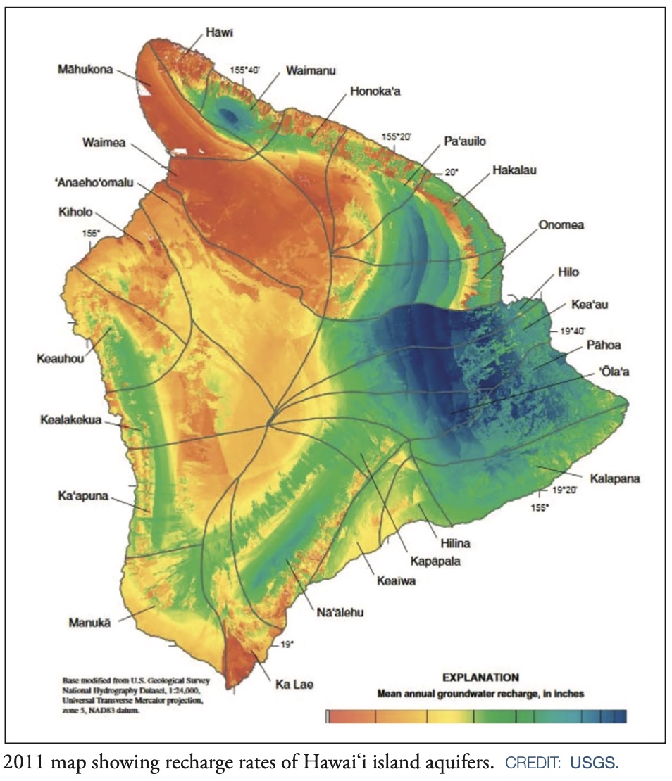
Look at a map of rainfall patterns on the island of Hawaiʻi. You’ll notice a slice of land in the northwestern part of the map that glows incandescent red, representing a climate that is a virtual desert. Data collected from a weather station in Waikoloa Village and published in the Rainfall Atlas of Hawaiʻi show that the mean annual rainfall for the area over the last 50 years amounts to just over 13 inches.
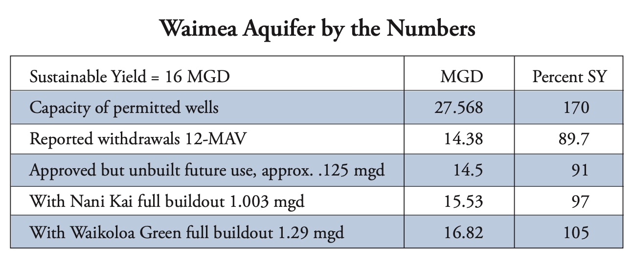
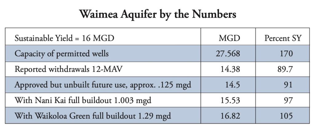
The Waimea aquifer lies entirely within this red zone. Groundwater needed to support the extensive resort developments along the coast and the sprawling Waikoloa Village is consequently limited. The aquifer’s sustainable yield, as reported in the state’s Water Resource Protection Plan, is estimated at just 16 million gallons a day, the smallest yield of all the aquifer sectors of the Big Island.
According to data provided by the state Commission on Water Resource Management, that groundwater source is severely stressed. The capacity of permitted wells is 29.75 million gallons per day (mgd), or 172 percent of the sustainable yield. Should all those wells be pumped to capacity, as they legally could be, the aquifer would suffer dramatically.
Look now at current pumpage: The 12-month moving average of actual reported pumping, as of April, stood at 14.35 mgd, or 89.68 percent of the sustainable yield.
The state Water Code, Chapter 174C of Hawaiʻi Revised Statutes, lists eight criteria for CWRM to use when deciding to designate an aquifer as a water management area, where users must receive permits from the commission for ongoing withdrawals. Among the criteria is this one: Whether an increase in actual or planned use “may cause the maximum rate of withdrawal from the ground water source to reach ninety percent of the sustainable yield.”
Even before withdrawals hit the 90 percent mark, the Water Code says, “the commission, when such level reaches the eighty percent level of the sustainable yield, may invite the participation of water users in the affected area to an informational hearing for the purposes of assessing the ground water situation and devising mitigative measures.”
Yet the Water Commission has done nothing.
Water Use
Of the 14 million gallons that are taken each day from the Waimea aquifer, about 3 million gallons are used to water golf courses and the landscaped grounds of the Waikoloa resort, fronting Anaehoʻomalu Bay. The Hawaiʻi County Department of Water Supply takes around 5.5 mgd to deliver to its customers. Some 5.8 mgd is drawn from wells owned by Hawaiʻi Water Service, a private utility that provides water to both Waikoloa Village and the Waikoloa resort.
That’s the current average use as reported by well permit holders over 12 months ending in April. Given that this is an average, there are bound to be days when withdrawals exceed the 90 percent threshold for designation set in the Water Code.
As for planned use, no one in any position of responsibility appears to be considering this. The Water Commission has not responded to questions Environment Hawaiʻi posed having to do with its monitoring of water use in the Waimea aquifer. The county Planning Department director, Jeff Darrow, said that he leaves it to the utility to determine if water supplies are sufficient to support the projects that come before his agency, as evidenced by a “will-serve” letter.
Environment Hawaiʻi reviewed a number of developments in the Waikoloa area that have received all necessary approvals and are in the process of being built, as well as projects that seem likely to win Planning Department and County Council approvals in the near future.
The approved uses include condominiums and apartments, as well as Phase 1 of Nani Kai, an expansive development of 78 luxury home sites immediately on the northern edge of the village. If each condo and apartment unit consumes roughly 250 gallons a day, and if the each of the houses in the luxury development consumes 600 gpd – which, in 2007, was the average household consumption in Waikoloa Village, according to Waimea Water Services, Inc. – that would add more than 125,000 gallons to the daily draw from the aquifer, pushing it well past the 90 percent SY threshold. If plans are approved for the full Nani Kai development – another 1,672 home sites – that alone would add more than 1 mgd to the total.
But the real water hog would be Waikoloa Green, which in June received the blessing of the Leeward Planning Commission to move forward. At press time, the rezoning and redistricting requests associated with this project were set to be heard on September 1 by the County Council’s Legislative Approvals and Acquisitions Committee.
Waikoloa Green
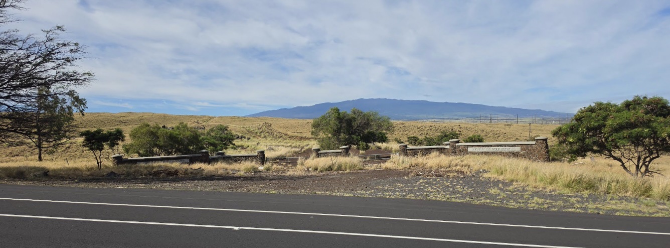
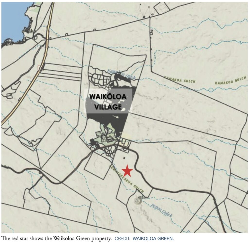
The 731 acres of former Parker Ranch land where Waikoloa Green is proposed is the site of two previous failed efforts at development. In the early 1990s, this area was approved for the Highlands Golf Estate, 400 ranchettes with a fancy golf club. That project did not get beyond construction of a rail fence and stone entrance gate, which may still be seen along Waikoloa Road.
The second moribund project was Waikoloa Highlands. Again, the planned 398 one-acre plus lots never materialized. In 2019, the parcel, placed into the Rural state land use district in 2008, was reverted to Agricultural by the Land Use Commission.
Sometime in 2021, Daniel Popkin, a New Jersey developer, and one-time Honolulu politician Jon Yoshimura began discussions with representatives of the landowner, Waikoloa Highlands. That September, the company that Popkin and Yoshimura had formed, Waikoloa Green LLC, entered into an agreement to purchase the land, and in April 2022, the sale was consummated, with a purchase price of $4 million – and a mortgage of $2.4 million.
As described in documents reviewed by the Planning Commission, the proposed zoning would allow up to 431 multi-family units, as many as 320 one-acre family-agricultural lots, and a maximum of 26 10-acre lots for “food hub and potential solar energy infrastructure.” The developer is also proposing setting aside more than 100 acres for open space and trails.
For all this, the water demand at full buildout is estimated at 1.29 mgd.
Yet when the Planning Commission discussed the project, scant attention was paid to the issue of water availability.
One person who did address this issue was Kanani Aton, who appeared before the commission both as a member of the public, testifying along with a few others, and as a consultant to Waikoloa Green.
But Aton’s references to water had nothing to do with the Waimea aquifer. Instead, she boasted of her role in getting the Water Commission to deny the petition of the National Park Service to designate the Keauhou aquifer as a water management area.
“The National Park Service was asking for a moratorium on all well development for the Kona side,” she said as she launched into a description of her role in the years-long negotiations that followed.
“We needed to educate the National Park Service that the unique footprint of water and water use development needed to have a unique perspective management according to the lay of the land here. …
“What happened was, we addressed the National Park Service’s concerns about water well development and impacts to Honokohau Park. We went over and we pulled weeds in the park and made sure that the park stewards were pulling weeds with us. And we made sure that they knew that it was also their stewardship principles that needed upgrades and improvement, to the way they managed their national parks, ʻcause they’re not in charge of our resources here.
“The people know what they’re doing and we know what we’re talking about and that was the most important thing, was to make space for that.”
Aton assured the Planning Commission that her involvement with the developers would ensure that all voices would be heard, should any conflict arise in the course of moving forward with the project.
Of the nine written favorable comments received in connection with the Planning Commission meeting, five were from Aton’s family members. One was from the Waikoloa Dry Forest Initiative, which has been promised a role in protecting rare trees in the project site. Others were submitted by Alex Sou of Aloun Farms, Alexander Lancaster, a rancher, and A. Lani Larrua, on behalf of the Waikoloa Village Association Board of Directors – although this was largely retracted by the WVA president in her testimony to the commission.
Waikoloa Brown
In fact, the Water Commission did submit comments of a sort on the Waikoloa Green application. Its views were solicited as part of the customary polling of state and county agencies to alert the Planning Department of any possible problems.
CWRM replied with a standard checklist of 20 possible responses, of which four boxes were ticked. The developer should coordinate with the county’s Department of Water Supply on the county’s Water Use and Development Plan update (last updated 15 years ago) and explore the use of “reclaimed water and alternative water sources for non-potable applications, including landscape irrigation, where practicable and available” (boxes 1 and 6).
The developer should also quantify potable and non-potable water demands in connection with subdividing the land and to confirm with the Department of Water Supply that system capacity is available to supply the project’s full build-out demand (checklist items 19 and 20).
Nothing in the Water Code puts the onus on the developer to confirm the availability of water, yet this is apparently CWRM’s standard response to any and all requests for input in areas that are not yet designated as water management areas.
What did receive plenty of attention from members of the public was the matter of fire vulnerability and the lack of adequate evacuation routes.
Matt Chalker, of the non-profit group Wildfire Safety Advocates, formed after the devastating 2021 Mana Road fire and the Lahaina fire two years later, said his group opposed the development, “unless and until the record establishes that the regional evacuation infrastructure to serve it exists or can reasonably be assured.”
“The applicant’s environmental report examines flood hazard (Flood Zone X), tsunami hazard (outside the evacuation zone), volcanic hazard (Lava Zone 8), and unexploded ordnance from the former Waikoloa Maneuver Area. It does not analyze wildfire. It does not analyze evacuation. Yet the applicant’s own botanical survey describes the parcel as ‘completely covered with grasslands,’ dominated by buffelgrass and fountain grass. That is precisely the flashy, fast-moving fuel that carried the Mana Road fire and the 2023 Lahaina fire.”
Chalker quoted from the Fire Safety Research Institute report, commissioned by the state Attorney General, that “assessed Waikoloa’s wildfire risk as marginally higher than that of Lahaina before its tragedy. To site hundreds of new households in that fuel bed, in the leeward corridor, and to discuss flood and tsunami while remaining silent on the one hazard that has already forced this community on the road, is not a complete record. It is the avoidance of the question.”
In her testimony to the Planning Commission, A. Lani Larrua, president of the Waikoloa Village Association, emphasized the same concerns, qualifying to the point of negating the written testimony submitted earlier.
“The approval letter sent under my signature,” she said, “was issued without the conditions of the WVA placed on record. … That omission was an oversight on our part, not a change in the WVA’s position.
“But I want to be direct with the commission today. These added conditions need to be addressed and this testimony restores them to the record. …
“Taken on its own, the Waikoloa Green proposal has merit and our endorsement reflects that. But the proposal must also be evaluated against its impact on the greater Waikoloa community. Considered in that light, much remains to be done before this project should be approved to proceed. The Waikoloa Village Association firmly believes that there is a critical public safety need in Waikoloa for additional permanent road infrastructure now. We have formally communicated this to both the mayor and the County Council and we are reiterating it here.
“Infrastructure capacity is already inadequate. The extended evacuation delay during the Mana Road fire in 2021 demonstrated that. Whatever the merits of the Waikoloa Green proposal on its own, the Planning Department’s failure to account for the additional risk it imposes on the community as a whole must be addressed before this project proceeds.
“In its current form, there is not sufficient basis to conclude that public health and safety are protected under foreseeable emergency conditions we ask the commission to apply a clear standard and to treat it as a condition of any future approvals, including this one. Do not approve additional growth until it is demonstrated based on existing and funded infrastructure that the community as a whole can be protected during extreme emergency conditions including evacuation.
“Please consider this testimony the controlling statement of the Waikoloa Village Association position superseding the prior letter to the extent it omitted these conditions.”
The Planning Commission had no questions of any of the testifiers. It advanced the proposal to the next step – consideration by the County Council of the boundary amendment application (14.6 acres for multifamily housing) and rezoning of the remaining acreage to categories consistent with the state Agricultural land use district.
A Transformed Worker Village
Waikoloa Village, home to around 7,000 souls as of the 2020 census, started out life almost as an afterthought to the development of resort areas along the Kohala Coast.
Recognizing the need to house the thousands of workers needed to serve the resorts, development began in the 1980s of a town around 6 miles inland from the Waikoloa resort. The land, once part of the Parker Ranch, soon saw modestly priced homes and condominiums sprouting up, along with a small commercial center and golf course, all of it built in accordance with covenants and restrictions governing everything from house paint color (requiring review by the village board) to junked cars (not allowed under any circumstance) to garden upkeep (monitored by regular patrols).
Today, the village has several low-income and “affordable” rental complexes where resort workers can afford to live, but the prices of market-rate condos and single-family homes has soared well past anything within the means of resort personnel.
Earlier this year, the median price of a single-family residence was $950,000, while few condos could be touched below $400,000. Long-term rentals of even modest three-bedroom homes start around $3,000 a month. Two-bedroom condos average around $2,500.
— Patricia Tummons